Intro
Design
Airframe
Hardware
Software
Testing
Launch 5
Glossary
Links
Contact
A Proposal for Simple, Parachute-Based
Landing Site Control
|
What and Why? |
|
As a result of the glider project, I've been contacted by quite a few
other high altitude ballooning groups who are interested in the idea
of being able to return to a controlled landing. But as you can see from this website, developing a UAV, especially
for high altitudes and at low cost, is a long, hard road, with a lot
of potential for equipment loss and damage.
While people working with parachute-borne packages can focus on what gear or experiments they carry aloft, most of my attention has been on how to get the glider to do something other than spiral earthwards at near-mach speeds. That means launching less, having to act cautiously, and spending far more time on planning and development. So some kind of compromise would be a good idea. At first glance a steerable parafoil for recovery would seem a good plan, but the control and stability problems are just the same as with a fixed wing aircraft, perhaps worse, with much lower glide performance. The largest benefit is a more robust craft. But one feature of the glider's software might be made to give a big improvement in landing site control to most groups, for very little extra cost or trouble.
When the glider ran a few months late in finishing, I ended up having a cloudy
pacific NW spring to ponder all the ways it could be lost or lose
control. So, I wrote a feature into the glider's ground software
that would allow me to use the timing of the chute release to
exert some control over the landing site, if it failed to achieve
controlled level flight.
To do that, the ground software records the wind vs. altitude on the way up (averaged to
get rid of velocity "noise" due to swinging under the
balloon). It then
constantly runs a little simulation of a descent under parachute to predict (roughly, of course) where the
glider would land if the chute were popped at that moment, and
shows it as an orange circle on the map display, with the circle's
size representing error margin. On the first flight (dive?)
this allowed for a landing on an island, instead of in the bay
next to it.
I've heard of a similar idea used by other balloon group's, carried out during their package's descent under parachute, so the recovery crew has some idea of where to drive off to. The primary improvement from what other people have done is to calculate and display the projected landing site in real time, allowing control, instead of just prediction of where it might splash down (or worse). By timing the chute release you may not get to choose the soccer field you'd most like to land in, but you can certainly choose between ocean vs. island, or lake vs. farmer's fields. |
|
|
|
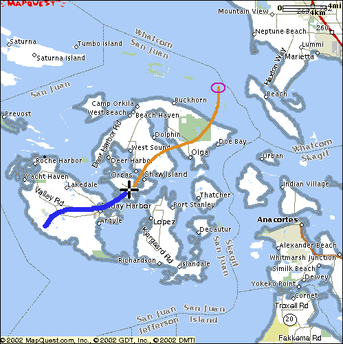
Below, I've pasted together a mock-up image of how this might look from
the software end. You'd have a map of your local area, hopefully
with the important features of interest (highways, bodies of water,
parks, etc). Along with the usual current position marker
(black cross), and ground track so far (blue line), the software would
also display where the package would land if the chute were hit
immediately (purple circle). A useful upgrade might be to have a projected series of landing options that will become available as the package falls (orange line). This could use the same code as that used to predict the current projected landing site, but just run through a hundred times to produce a spread of sites. Ideally, the current descent rate while "skydiving" would be used to fold the drift that will occur during further freefall into the calculation of that trail of landing sites. The software used to record winds on the ascent, preferably to disk, and then project the landing site, can be fairly simple. The little descent simulator for the glider took less than 100 lines of C code. I would expect the full system would still be less than 1000 lines, IE, a few evening's work. The hardest part, IMHO, is to find a good map display library (mine only displays shorelines), and to arrive at a widely useful standard for telemetry input. The mockup map below shows the American gulf islands, near Seattle.
You can see how at first glance this would be an unwise place for a local
balloon group to launch from - but with some control over the landing
site, it could work out just fine. Not only could you be fairly certain of
landing on one of the islands, but you could even aim for within the
public park on Orcas island (in green). |
|
|
|
|
|
For the most basic use, a flight package with an ordinary parachute plus
cut-down device would do. You would just trigger the balloon release
when it appeared the projected landing site was clear of major
hazards. This is a bit lacking though, as then you can't fly up
to max altitude every time, and the accuracy of the landing site projected
will be quite poor if a large, slow chute is used from a very high
altitude.
But ideally, you would use two parachutes, one a small drogue of maybe 0.3m diameter, plus your regular main of around 1.5m, with two release gizmos, one from the balloon, and one for the main chute. You can then do a two-stage descent, allowing the package to fall after cut-away under the drogue alone, until the projected landing site is over an area the ground crew is happy with (and someone with good reflexes can trip for accurately!). An obvious benefit is that the closer to ground level the main chute is tripped, the more accurate the landing site projection. The small drogue would best be on a fairly long line, say 10 feet, and might use fine mosquito type mesh for shrouds as they do with skydiver drogues, so it can't tangle (or you could just get an old skydiver drogue chute). The purpose of the drogue is to give the package a controlled, predictable freefall, without tumbling, and to keep the descent speed from getting too extreme. You'd also be best to pack the main for high-speed deployment to avoid a shock opening. If you haven't made your main chute yet, I'd strongly recommend putting a vent in the top, of say 15% or more of the total diameter. This much reduces oscillation during descent, making for a better camera platform, and steadier, more predictable descent rate. Richard Nakka has an excellent site on parachute design and construction that can help you make a good chute. Following his method, the glider's landing chute was made in about one full day. |
|
Flight Testing |
|
One hang up is that for the landing site predictions to be at all
accurate, you have to get an accurate estimate of the performance of
your main parachute. A parachute's descent rate varies quite a bit with
how much it sways, etc, so actual test data from a decent altitude would
be required, which would then have to be corrected for density altitude. It would be nice to also have a number for the drogue's performance as well, to increase the accuracy of the displayed "projected landing sites track" as per above while still ascending under balloon, but this is less critical. The landing-projection software can also just estimate the drogue's performance using real time data during the free-fall descent. The calculations required to adjust vs altitude and payload mass can be easily included in the software, but at least one test flight would be required for the software to be accurate with a given set of parachutes. Changes in package weight would not require a new calibration flight, but changes re the chutes probably would. |
|
|
|
|
written by Art_Vanden_Berg
|