Intro
Design
Airframe
Hardware
Software
Testing
Launch 5
Glossary
Links
Contact
Is there Any Risk to Aviation?
| For those involved in aviation, small
Unmanned Aerial Vehicles (UAVs) such as the glider this website
describes may seem to present a new risk of mid-air collisions, in
addition to the older risks of birdstrikes and other aircraft.
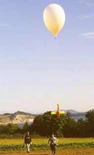
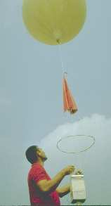
In fact, the risk is both old, and has already been shown to be very small. Weather services around the world have been launching "unmanned free balloons" (named radiosondes) unannounced for many decades, by the millions, and of comparable mass.
Such balloons packages are visible on the ascent, but not on descent; their parachutes are small, and they descend at a fairly high rate. The payloads tend to mass between 0.3 kg and 2.5 kg, and are limited to this size range by regulations in Canada and the United States (Canada limits balloon volume, while the US sets the limit as an approximately equivalent payload mass). Larger balloon launches require a permit, and a notice to airmen (NOTAM). The purpose of a balloon launch is not dealt with by the regulations. |
 From
the point of view of risk of collision with a transport category or
light aircraft, there is no difference between these balloon packages,
and a small high altitude UAV of the same scale (2.5kg or less). From
the point of view of risk of collision with a transport category or
light aircraft, there is no difference between these balloon packages,
and a small high altitude UAV of the same scale (2.5kg or less).
The airspeed of a small UAV at the altitudes larger aircraft fly at, is a fraction of those larger aircraft; therefore from the point of view of kinetic energy, such a UAV can be considered almost static, at most making it 1.5x larger in effective mass. (While the glider described on this website can fly at high speed, it only does so at altitudes well above those at which airliners fly). Thus, the only variance between a balloon package descending by
gliding, versus by small parachute, is that the glider has a good chance
of controlling its descent flight path, and where it lands.
While gliding, under Transport Canada regulations, as long as the total
mass is under 35kg and it is for a recreational purpose (such as
incredible photos!), the glider can be considered a "model
aircraft". |
|
But what is the risk level? |
|
However, the authors of this study limited their model to UAVs that fly at 10,000 feet or below. For one that flies higher, a rough estimate (such as may be found below for GA aircraft) puts the risk 10 to 100x higher; still comfortably in the 1 in 10 million to 1 in 100 million range. This is corroborated by the perfect safety record to date of weather balloon launches; in fact, radiosonde balloons are often considered to be current-day small UAVs. Of interest, the MIT study put the risk to people on the ground from a falling UAV of this scale to be easily held down to the 1 injury per 100 million flight hour range, as long as urban areas are avoided. Fail-safe parachute systems can reduce this risk even closer to zero (if control is lost, or the computer fails, the chute opens). A major drawback of the MIT study, however, it that it seems to only model risk to transport category aircraft and people on the ground, and entirely ignores light aircraft.
|
|
So, what about Light Aircraft? |
First, some statistics. The general aviation (ie, light aircraft, not transport category aircraft) accident rate is on the order of 10 incidents per 100,000 flight hours, with about 1% of those mid air-collisions. So as a ball-park figure, put the mid-air rate at 1 / 1,000,000 flight hours. A small UAV's risk of collision should aim to be below this level. In other words, there should be no substantial additional risk. Using a similar, though less detailed, mid-air risk estimating model to MIT's, what then is the approximate chance of an interaction with a light aircraft? We'll use the "worst case" scenario; launch and landing in rural Fraser Valley, the busiest light aircraft region in BC.. To start, Canada’s general aviation fleet is estimated to fly about 2.5 million hours per year. As a rough estimate, let's say the Fraser Valley's share of that is about 150,000 hours per year; probably a bit high, but this is trying to be conservative. We'll assume 100,000 of those are daylight hours. As a typical aircraft, assume a Cessna 172, of about 3 m2 frontal area and 100 kts cruising speed. GA aircraft should thus sweep a volume of about 1x10^7 m3 per average daylight hour in the Fraser Valley. For altitude, take a range of 1000 to 8000 feet. As to area, the east end of the Fraser valley, over which ascents and descents would occur, we'll place at an area of 1500km2, for a total volume of about 3x10^12 m3. Compared to a GA aircraft, UAV's frontal area is small enough to be ignored for this analysis. This leaves a chance per daylight hour of intersecting a small randomly placed aerial object at 1 in 300,000 flight hours, assuming no effort is made to avoid airports, practice areas, or traditional waypoints. But GA mid-airs overwhelmingly occur in clear daylight, in the vicinity of airports, and either in the approach path to landing, or at the discrete altitudes light aircraft often fly at (1000', 1500', 2000', etc). In addition, flight tracks generally begin and end at an airport or common waypoints. These facts are largely responsible for the low risk estimate above. They also tell us that by actively avoiding GA airports and practice areas the risk can be brought substantially below that value. With this in mind, the next version of the glider will include an in-software list of areas to automatically steer clear of, without needing to be commanded by an operator. This will also provide for some measure of terrain avoidance, in addition to parachute triggering at a safe altitude if it finds itself over the mountains. |
|
What's the per-flight risk? |
|
On ascent, the balloon is large, visible and low in mass; the string is cotton twine with an under-25 pound breaking strength. The only risk might then be from the < 2.5 kg, foam and thin plastic glider, which when gliding, and not under parachute or balloon, is too small to see reliably. Essentially, it has about the size, weight, visibility, and sea-level airspeed of a small Canada Goose, but doesn't number in the millions, and can be a little smarter about avoiding airports. So, we'll just apply the general analysis for UAVs given by the previous section. Near sea level, the balloon ascends at about 1000 fpm, and the glider descends at about 500fpm. Total time per flight spent between 8000 and 1000 feet is thus about 0.5 hour. Thus, making the worst-case assumption that no effort is made to avoid active GA airports or practice areas, and that GA aircraft see neither the balloon nor the glider, the total risk of collision by a light aircraft in the Fraser Valley is around 1 chance in 600,000 per glider flight. This risk can be reduced to a negligible value by simply avoiding airports and practice areas.
|
 In
North America alone, there are 150 radiosonde launch sites, most of
which launch small packages twice daily, for some 100,000 launches each
year. A large number of these launch sites are in high-traffic east
coast areas; some even located on airport land. Locally, there are 3
such regular launch sites in NW Washington state, and south western BC,
in addition to several irregular launch sites. In decades of
launching at this rate, with millions of total launches, there has
not been a single reported incident of a mid-air collision with a
balloon package, either on ascent or descent (some have, however,
been spotted by airline pilots).
In
North America alone, there are 150 radiosonde launch sites, most of
which launch small packages twice daily, for some 100,000 launches each
year. A large number of these launch sites are in high-traffic east
coast areas; some even located on airport land. Locally, there are 3
such regular launch sites in NW Washington state, and south western BC,
in addition to several irregular launch sites. In decades of
launching at this rate, with millions of total launches, there has
not been a single reported incident of a mid-air collision with a
balloon package, either on ascent or descent (some have, however,
been spotted by airline pilots).